


Enjoy this guided walking tour of St Ninian’s Isle, by Gill Nadin
Photography By: Alexander Mazurov, Susan Molloy and Misa Hay
No Shetland adventure would be complete without a recommendation to visit St Ninian’s Isle.
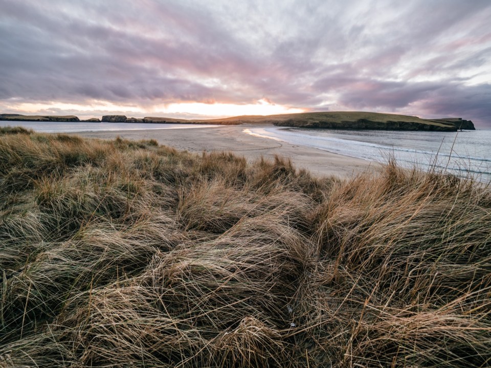
It is not an island in the usual sense. You can walk across it most of the time, as it is joined to the South Mainland of Shetland by a tombolo – what a wonderful word. The various dictionary definitions of “tombolo”, which approximate to… “a sand or gravel bar connecting an island with the mainland or another island,” really do not do justice to this stunning double-sided sandy beach. Over 500m long and normally about 20-40m wide, made of white sand with the North Atlantic approaching from both sides, it is a must-see for Shetland visitors.
Why we love St Ninian’s Isle
It is the start of a relatively easy walk that takes in stunning coastal scenery, sea stacks and cliffs, stories of buried treasure (twice), seabirds, seals, archaeology, glimpses of Shetland’s social history and some inspirational young farmers. St Ninian’s Isle and tombolo are at Bigton. There is a limited bus service to the village, so most visitors arrive by car.
As you head down to the beach, there is a great view of the tombolo, even on a dull day; when the sun shines it can be breath-taking. The large farmhouse to your left is the home of the Budge sisters; young farmers who took over the farm in tragic circumstances a few years ago but have won several awards for their farm management; they recently featured in a BBC documentary series called This Farming Life. You will get a better view of the farm from the island, where they graze some of their sheep.
Parking is normally no trouble; only on very warm sunny days in Shetland do any of the beaches get remotely “busy”. On most days you will not have to share the sand with too many folk, so head onto the tombolo and across towards the Isle, perhaps pausing to paddle, marvel at the variations in rocks and pebbles, gaze at the wonderful vistas or simply absorb the atmosphere.


St Ninian’s Isle is filled with adventures
My personal favourite is to watch the spindrift (the tops of waves blown off by the wind) as it dances, drifts and flies. Depending on the time of year, there may be lots of birds around. Fulmars and gulls will soar overhead all year round, but you may also see black guillemots, divers, shags, various waders, ducks and many more. On the beach you may be mobbed by arctic terns in the summer; beautiful but feisty birds with long forked tails and very sharp beaks that they will use to attack if you get too close.
The most strenuous part of our ‘easy’ walk follows – one step forward, two steps back – up the soft sandy track at the far end of the beach. When you get to the flat grassy top beware! The local rabbits love the sandy soil and there are burrows galore, so please watch your footing. Looking down will also ensure you do not miss the wonderful wildflowers on display in the summer. All plant life in the islands has had to adapt to the exposed and usually windy conditions, so it tends to hug the ground. There are short, but beautiful flowers to look out for – blue spring squill, pink thrift, heath orchids, silverweed with its bright yellow flowers and wondrous silver leaves, wild thyme, tormentil and many more, including my personal favourite, eyebright.
Now you are on the island, there are several options for walking and unless your sense of direction is dreadful or the mist comes in, navigation is not a problem. An obvious choice is to walk the complete coastline – simply choosing clockwise or anti-clockwise. This is a great option if you have the time and the total walk from the car park and back is between three and three and a half miles – five or six kilometres. It is relatively easy going for most of the route, but do not expect a path (apart from some sheep tracks). There are stiles to help you get over the wall and fences, so please use them.
Just out of view to the right as you get onto the island is a ruined chapel site – the location for our treasure stories (grid ref. HU 3685 2090). Many visitors simply walk there and back. Another alternative is to walk part of the coastline and use a short-cut back across the centre of the island. More choices again; you can either walk the north or south part of the island and choose clockwise or counter-clockwise.
As you walk around the isle, please be careful. The coastal scenery is spectacular, but special care should be taken near cliff edges (even low cliffs) as the ground may slope towards the edge and be very slippery. There are narrow gullies to watch out for and you may not spot them until you are almost upon them. Some cliff edges are undercut or unstable, so do not assume there is a substantial rocky support under the cliff you are standing on.

Best times to visit
You are free to wander anywhere on the island. However from May to August, it is recommended you stay around the coast in the northern half, to reduce disturbance of ground- nesting birds, including the bonxies (the dialect name for the great skua). Globally rare, they are doing very well in Shetland and perhaps half of the world’s population is found in the islands. They are large birds who do not like visitors near their nests. They will watch you closely from a distance, but if you get too close, they will fly at you and thump you on the head or shoulders with their feet. Also keep an eye out for their smaller relative – the arctic skua. One of my favourite birds; stealthy, sleek, and agile with an unusual pointed tail, they are also rare. They have a well-earned reputation as avian pirates, stealing much of their food from other birds, hence their American name of parasitic jaeger.
One small feature to take in now, is St Ninian’s Well – you might forget it later. From where the sandy track flattens out onto the grass, head diagonally to the left, slightly downhill and about 150-200m away in a marshy area you will find the natural water-source, described as an ancient well (HU 3667 2068). Although the island is now inhabited only by sheep and the local wildlife, until the 1790s several families lived here. Their small houses were dotted around this area. They left when their fuel source (peat) ran out on the island and all the stone from their houses was used by the landowner to build the massive wall across the isle. In most areas of Shetland, we still see ruined, abandoned croft houses, which offer glimpses of how the land was used and life was lived, but not here. Fine, even grassland now covers the whole area where the rigs (fields) were once cultivated. However, occasionally in low light, traces of the old rig boundaries can be seen.


Gill Nadin, shares some of her best kept secrets from St Ninian’s Isle
There are many beautiful spots to explore around the island, but I will describe my favourites. Selchie Geo is a spectacular feature on the west side of the island, with sheer cliffs where you may spot a few puffins or kittiwakes nesting. Selchie (or selkie) is the dialect word for seal, and they are often seen in the geo, but you may see them anywhere. Both grey and common (or harbour) seals are a frequent sight around our coastlines. Selkies are also mythological creatures – seals in the water, but they can take off their skins and become human on land. If an ordinary mortal sees a Selkie in human form, they will fall in love. The Selkie legend has several variations but rarely ends happily.
Near to Selchie Geo is a ruin of a hut, used as a watchtower in World War I. It can provide a little shelter from the wind for a picnic on a blowy day. It was near the ruin that I spotted a treecreeper on the ground a couple of years ago – a small bird that had clearly lost its way on this treeless island!
St Ninian’s chapel ruin is surrounded by a small fence to keep out the sheep. The church was used until the early 1700s, then it filled with blown sand, but the churchyard continued to be used for burials until about 1840. The site has a long history; St Ninian himself (an important figure in Scottish Christianity) never came to Shetland but his followers arrived about 600AD.
My favourite place on the island is Loose Head at the northern tip. There is a trig point at the ‘summit’ (only 59m) but despite the lack of height it is a spectacular spot, with views up the coastline of Mainland Shetland to Burra and the Westside. It is a great place for a picnic on a calm day. If the sun is shining, the cliffs near Westerwick around 12 miles away may display their wonderful rich red hues. About 3 miles to the north of Loose Head is the island of South Havra; now uninhabited, it used to sustain a population of up to 50. There was no stream on which to build a small watermill to grind grain (as was usual in Shetland). Instead they had Shetland’s only known windmill for grinding and the ruin of the tower is still visible.
St Ninian’s Isle and tombolo is a wonderful place to visit, whatever time of year. In the depths of winter in a flying gale (with appropriate clothing and caution of course) it is an exhilarating spot where you can really experience the power of nature. On a calm summer’s day, it is difficult to imagine a more perfect spot to explore and appreciate our wonderful islands. I hope that you have a sense of what it may offer, and you are now keen to experience it yourself.
If you are dreaming of travelling to Shetland – purchase your copy of the Shetland Wool Adventures Journals.
In these journals you will discover secret Shetland Island hiking trails, beautiful Shetland Island photography and more about this unique Scottish travel destination.

Be The First To Comment